fontanelle_quartieri Which are the main metrics for the project by using Geopandas, Folium , Matplotlib¶ Here more info about Acquamat, a crowdsourced map of drinking water spots scattered throughout all… Read more »
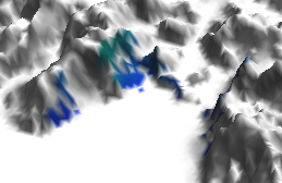
A QGIS guideline about the viewshed of a point on a digital elevation model and how it is possible to filter out points which doesn’t fall in line of sight (LOS)
In order to celebrate this space, I decided to show some pills of Open Source philosophy, which is applicable to other fields of life as well (Italian slides). Filosofia open… Read more »
![Diapositiva1[1].PNG](https://www.nicoladeinnocentis.it/sito/wp-content/uploads/2017/10/Diapositiva11.PNG)